Data Center Site Selection: The Due Diligence Step Most Teams Skip
Most site searches underwrite land, power and fiber, then meet the ordinance during entitlement. Here is how to screen an address against the public record first.
Most data center site selection work begins with power and land. Consequently, it often ends in a county commission meeting nobody on the deal team saw coming. The parcel was fine. The record was not.
There is now a public record of why these projects fail. Moreover, that record is large enough to screen against before you spend money. SAVRN built Site Intelligence to do exactly that. You type an address. In seconds you see every moratorium, grid restriction, and documented project failure on file for that location.
This piece explains what the tool reads, where the underlying data comes from, and why screening an address belongs early in diligence rather than late.
What actually kills a data center project
Deal teams underwrite three things well. Specifically, they underwrite land, power capacity, and fiber. Those are the things a broker can show you.
However, the failure modes that stop projects are usually somewhere else. A county passes an interim ordinance. A grid operator suspends its large load study process. A state regulator opens a docket on who pays for transmission upgrades. None of those appear on a site brochure.
Furthermore, these events are not rare anymore. They are frequent enough to have a shape, a geography, and a citation trail. Therefore they can be measured, and anything that can be measured can be screened.
The record exists, and it is already public
Every one of these events leaves a paper trail. For example, a moratorium is an ordinance. A grid restriction is a market notice or a docket. A cancelled project is a filing, a press release, or a council vote.
SAVRN maintains four running records of that trail. In addition, each one is public, dated, and cited to its source document. Site Intelligence reads all four against a single coordinate.
The Moratorium Tracker
The Data Center Moratorium Tracker follows where communities have restricted data center development. At present it carries 242 local moratoria across 36 states with restrictive action, supported by 246 primary sources.
Importantly, a moratorium is a land use instrument, not a mood. County and municipal governments use it to pause approvals while they write standards. The American Planning Association documents the interim ordinance as a standard tool in exactly this situation.
Consequently, the practical question is never whether a community likes data centers. Instead it is whether an ordinance binds your parcel today, and when it expires.
Jurisdiction matters more than most teams expect. A city measure inside a county does not bind unincorporated land in that same county. The National Association of Counties exists partly because county and municipal authority genuinely differ. As a result, Site Intelligence treats a municipal measure as county context rather than a county wide block.
The Delay Watchlist
The Data Center Delay Watchlist is the record of what already went wrong. Currently it tracks 224 named projects that were delayed, cancelled, or placed under review.
This tracker answers a different question than the moratorium record. Rather than asking what rule applies, it asks what happened to people who tried. Comparables are the oldest tool in real estate diligence, and this is the comparables table for failure.
Additionally, each entry carries a cause and a first delay date. Therefore you can see whether a region’s problem is water, zoning, transmission, or local opposition, and whether it is getting better or worse.
The Grid Operator Watchlist
The Grid Operator Watchlist covers the market layer. It holds 93 rulings and filings on record across every RTO and ISO, supported by 114 primary sources.
This is the layer most site searches miss entirely. A balancing authority ruling governs every large load in its footprint. Notably, it does not care which retail utility serves your particular parcel.
For instance, if a grid operator suspends its large load interconnection process, that suspension applies to your site whether or not you have identified your utility. Because of that, Site Intelligence now leads with the market fact when one is in force, and treats an unidentified utility as a secondary gap.
The Capital Atlas
The Capital Atlas tracks announced capital across North America. It supplies the competitive picture around a location.
Capital concentration is a two sided signal. On one hand, it indicates that power and fiber exist. On the other hand, it predicts queue congestion, labor scarcity, and political fatigue.
Engine zero: who actually serves this parcel
Before any of the four records can be applied, one question has to be answered. Specifically, which utility serves this exact piece of land, and who regulates it?
That question is harder than it sounds. Service territories overlap on public maps. In competitive retail states the wires company and the retail provider are different companies. Furthermore, electric cooperatives serve enormous areas that many people assume are investor owned, and the National Rural Electric Cooperative Association counts more than 900 of them nationally.
Site Intelligence resolves an authority chain rather than a single name. It separates the serving utility, the distribution operator, the load serving entity, the balancing authority, the RTO or ISO, the state retail regulator, and any local governing board. Because retail regulation differs by state and by ownership type, the work of the National Association of Regulatory Utility Commissioners is a useful reference on why that separation matters.
Critically, the tool fails closed. If two retail territories overlap and the record cannot settle which one serves the parcel, it says so. It does not guess a utility from the state, and it does not present a guess as a finding.
The federal layers underneath
Alongside the SAVRN trackers, the screen reads federal and international datasets for physical context.
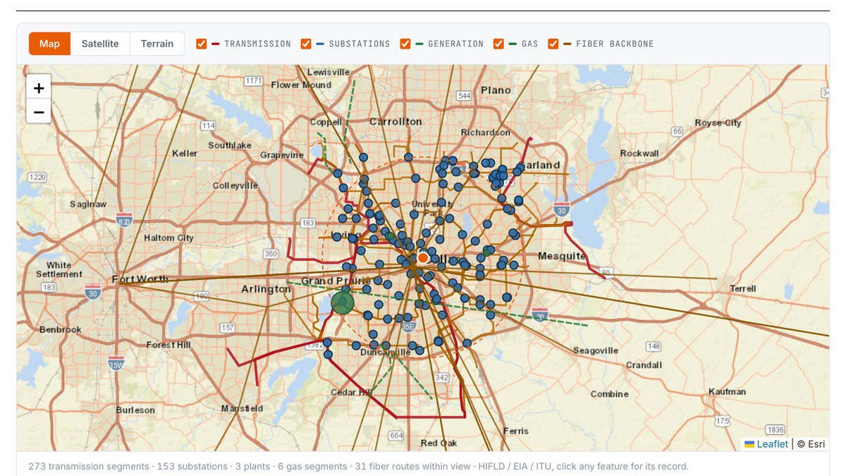
Transmission lines, substations, and pipeline data come from the geospatial infrastructure layers maintained by the Department of Homeland Security. Generation data comes from federal energy statistics. Terrestrial fiber routes come from the International Telecommunication Union backbone map.
Risk layers come from the same places an insurer would look. Flood and multi hazard exposure come from the FEMA National Risk Index. Seismic hazard comes from the United States Geological Survey. Water stress comes from WRI Aqueduct. Incentive context includes federal Opportunity Zone designation.
Consequently, the screen is not an opinion about a region. It is a set of public records read against one coordinate.
What a screen actually returns
The output is organized as an underwriting decision rather than a data dump. Above all, it is built to answer whether to proceed.
First, it returns a decision. The decision names what controls it, and it names the single fact that would change it.
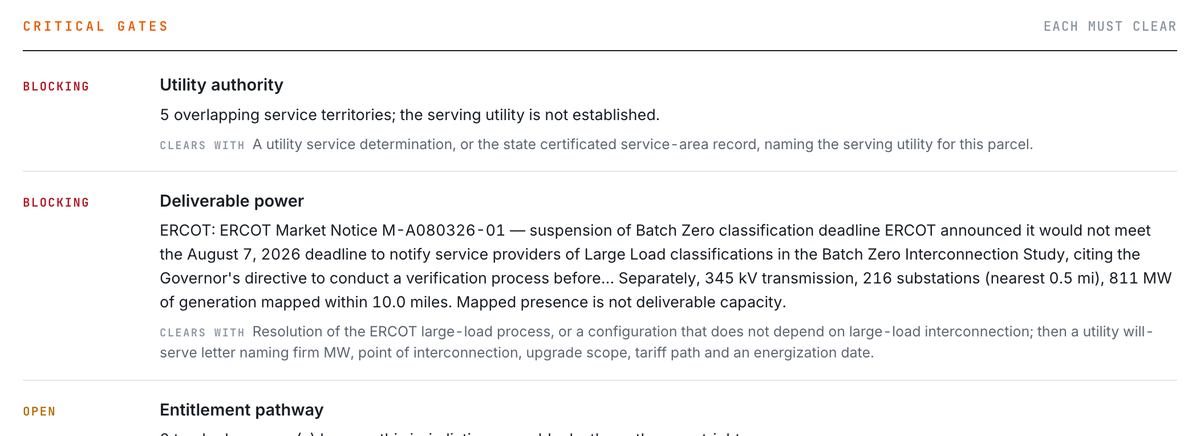
Second, it returns critical gates. Each gate is either clear, blocking, or pending, and each blocking gate states the specific document that would clear it.
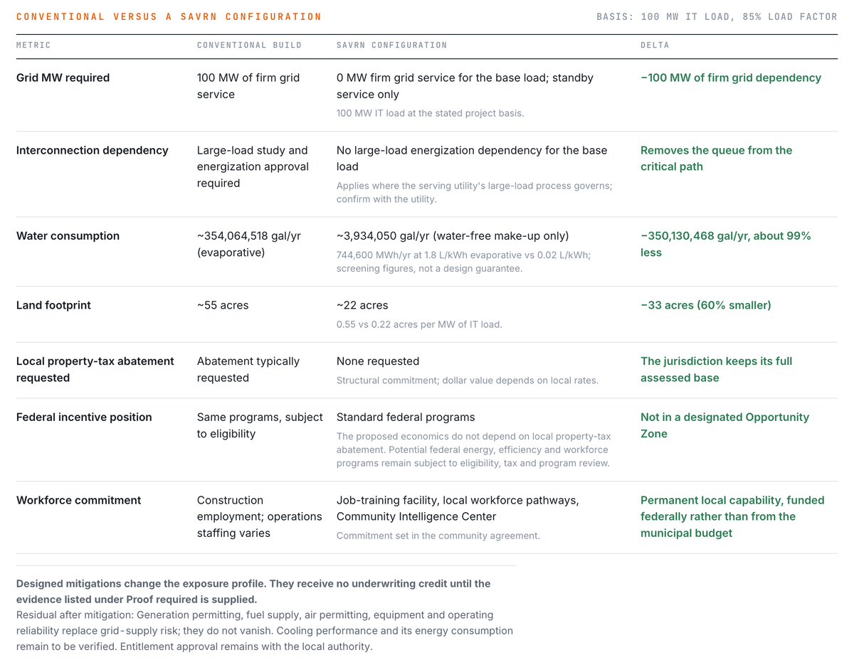
Third, it returns the exposure and the delta. In other words, what a conventional grid served configuration is exposed to here, and what a self powered configuration changes about that exposure.
Fourth, it returns the proof required. This is the list of documents a lender or a committee will ask for, generated for that site.
Finally, every finding links to its source. The trackers publish dated changelogs and full citation lists, so any finding on the screen can be walked back to the filing it came from.
Reading a real result
Consider a downtown Dallas address today. The serving utility does not resolve cleanly, because several retail territories overlap that area on the public map.
An older screening approach would stop there and report that the utility is unknown. That answer is technically true and practically useless.
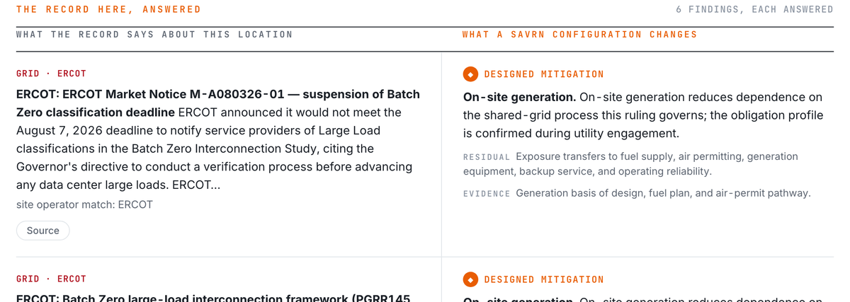
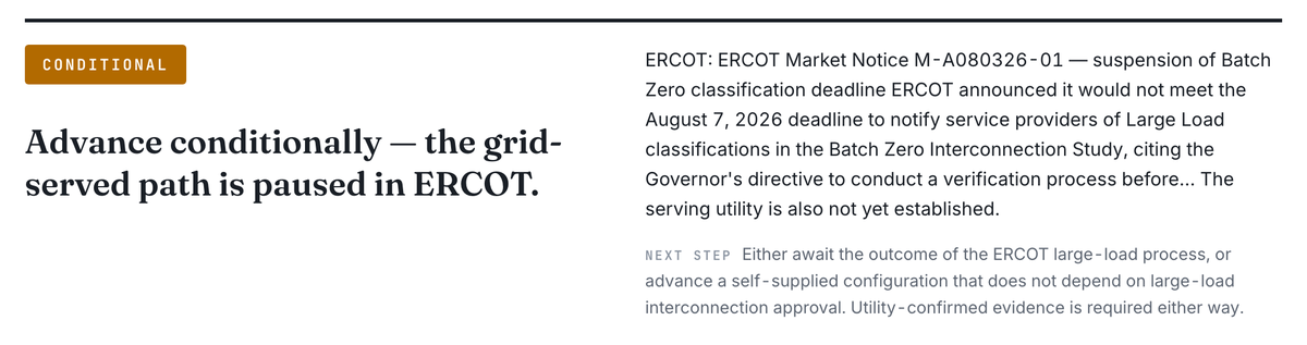
The controlling fact in Texas right now sits at the market layer instead. ERCOT suspended a large load classification deadline, and a state directive put new large load interconnection under audit. Therefore the screen reports that the grid served path is paused in ERCOT, names the market notice, and offers two paths forward. Either await the outcome of that process, or advance a configuration that does not depend on large load interconnection approval.
The unresolved utility still appears. However, it appears as a secondary item, because it is not what governs the decision.
Where this belongs in your sequence
Screen the address before the site visit. Screening costs nothing and takes seconds.
The conventional order is to tour, then negotiate an option, then discover the ordinance during entitlement. Meanwhile the option payment is spent and the schedule is public. In contrast, a screen at the top of the funnel removes sites before they consume capital.
Additionally, a screen is useful on sites you intend to pursue. It produces the proof list early, which shortens the gap between letter of intent and financeable diligence.
What the tool does not do
It does not replace counsel, a utility service determination, or an interconnection study. Nor does it promise capacity.
A mapped substation is not deliverable power. Only a will serve letter naming firm megawatts, a point of interconnection, upgrade scope, tariff path, and an energization date establishes that. The screen says so explicitly rather than implying otherwise.
Finally, it does not predict outcomes. It reports the record as it stands on the date it was verified, and it shows you that date.
The argument in one line
A project that clears the interconnection queue and fails the county is still a failed project. That failure is documented hundreds of times over in public records. Consequently, reading those records against your address is not an optional refinement of data center site selection. It is the cheapest diligence step available, and it belongs first.
You can run any United States address through Site Intelligence at no cost. For the reasoning behind how SAVRN approaches the communities that host these projects, see Give more than you take.
Want the next one?
When a new piece publishes on SAVRN Insights, you get one email with what it covers and a link to read it. No digests, no promotions.
One email when it publishes. Unsubscribe in one click. Privacy
Frequently asked questions
What is data center site selection?
Data center site selection is the process of identifying and qualifying a location for a data center. It weighs power availability, land, fiber, water, climate, workforce, incentives, and regulatory risk. Increasingly, the regulatory and community layers decide the outcome.
Why do data center projects get delayed or cancelled?
Projects most often stall on local restrictions, interconnection constraints, water concerns, and organized community opposition. The SAVRN Delay Watchlist currently tracks 224 named projects that were delayed, cancelled, or put under review, each with a documented cause.
What is a data center moratorium?
A moratorium is a temporary local restriction that pauses approvals while a jurisdiction writes new standards. It is a normal land use instrument rather than a permanent ban. The important questions are whether it binds your specific parcel and when it expires.
Does a city moratorium apply to the whole county?
Usually not. A municipal ordinance binds land inside that municipality, while unincorporated county land falls under county authority. Site Intelligence treats a municipal measure as county context and does not escalate it into a county wide block.
How do I find out which utility serves a specific address?
Public service territory maps frequently overlap, so a single map lookup is unreliable. Site Intelligence resolves an authority chain that separates the serving utility, distribution operator, balancing authority, RTO or ISO, and state regulator. When the record cannot settle it, the tool reports the ambiguity instead of guessing.
Why does the balancing authority matter more than the retail utility?
A balancing authority ruling governs every large load inside its footprint. As a result, an interconnection pause applies to your site regardless of which retail provider serves the parcel. That makes the market layer decisive even when the utility is still unidentified.
Is Site Intelligence free to use?
Yes. Screening an address is free and requires no account. Building the full Site Infrastructure Dossier for a location requires an email address, which is used to open that document.
What data sources does Site Intelligence use?
It reads four SAVRN trackers covering moratoria, project delays, grid operator rulings, and announced capital. Alongside those, it reads federal and international datasets for transmission, substations, generation, pipelines, fiber, flood and seismic hazard, water stress, and incentive designation.
How current is the underlying data?
Each dataset carries its own verification date, and the screen displays that date. Each tracker also publishes a dated changelog and a complete citation list, so any finding can be traced to the filing it came from.
Does a screen replace utility and legal diligence?
No. It is a screening instrument that tells you where to look and what to ask for. Firm capacity still requires a utility will serve letter and an interconnection study, and entitlement questions still require counsel.